user_mobilelogo
Facebook
Freitag, 03 Juni 2016 12:06

Ein kleiner Frustbeitrag zum Thema Morgennebel

Ein kleiner Frustbeitrag zum Thema Morgennebel

Seit über einer Woche bildet sich jeden Morgen eine graue Wand, die mich davon abhält die Fortsetzung zum ersten Teil des Videos über Landschaftsfotoplanung zu drehen. Ein ganz normaler Sonnenaufgang wäre schon vollkommen ausreichend, doch stattdessen hängt die Sonne jedes mal noch für Stunden hinter einem Vorhang aus Morgennebel. Aus heute war es wieder so. Ein Ärgernis, dass mich aber dazu brachte, der Sache mal theoretisch auf den Grund zu gehen! 


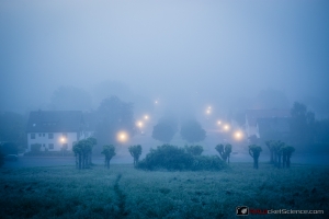
Natürlich habe ich das sprichwörtliche Grauen schon weit vor dem Aufgang der Sonne bemerkt. Und natürlich hätte ich mich gar nicht erst auf den Weg machen müssen, nachdem der Blick vom Balkon um 3 Uhr nachts bereits nichts gutes verhieß:

  • IMG_3001
 

Warum ich trotzdem losgezogen bin? Weil es schon seit einer Woche nicht anders aussah und ich die Schnauze voll hatte. Weil mein Fotospot leicht erhöht liegt, vielleicht könnte ja ich über den Nebel hinwegfotografieren, aus dem optimalerweise nur die Kirchturmspitzen herausragen und es würde sogar richtig gut aussehen? Weil der Nebel sich bis zum Sonnenaufgang in zwei Stunden vielleicht eh wieder verzogen haben würde? Weil ich ja immerhin auch Sterne sehen konnte, wenn ich senkrecht nach oben geschaut habe? Wie sich herausstellen wird, waren meine Hoffnungen unbegründet, fast naiv. Als ich am Zielort ankomme, scheint sich das ganze noch verschlimmert zu haben, man sieht gar nichts.

  • IMG_3013
  • IMG_3022
 

Um dieses Ärgernis zumindest besser zu verstehen, es beim nächsten mal besser abschätzen und vielleicht ja sogar gestalterisch auch mal ausnutzen und vorhersagen zu können, folgt nun also die theoretische Auseinandersetzung:


Was ist Morgennebel?

Morgennebel ist nichts anderes, als eine Wolke in Bodenhöhe. Tausende winziger Wassertröpfchen schweben in der Luft und rauben so die Sicht.


Wann kommt Morgennebel?

Die kurze Antwort: besonders, wenn es am Tag zuvor warm war und eine sogenannte Hochdruckwetterlage besteht, also vor allem bei schwülem Wetter. Da gibt es meist keine oder nur wenige Wolken und wenn es dann Nacht wird, strahlt der Erdboden seine Wärme zurück ins Weltall. Dabei kühlen sich die bodennahen Luftschichten ab. Kalte Luft kann leider weniger Wasserdampf aufnehmen als warme Luft, d.h. ihr Taupunkt wird schneller erreicht, die Feuchtigkeit der Luft beträgt also 100% und der Wasserdampf kondensiert als flüssiges Wasser aus. Das sind dann die Tröpfchen, die den sichtbaren Nebel am nächsten Morgen bzw. schon in der Nacht bilden und mich die letzte Woche jedes mal den Sonnenaufgang gekostet haben.


Wann verschwindet er wieder?

Meine persönliche Antwort: leider nicht so schnell wie ich gerne hätte! Auch am heutigen Morgen konnte ich zwar erahnen, dass da hinterm Grau irgendwo die Sonne aufgeht, aber gesehen hab ich das nicht:

  • IMG_3032-2
  • IMG_3032
 

Wenn man sich mal bewusst macht, was es braucht um den Nebel wieder verschwinden zu lassen, wundert einen das aber auch nicht. Natürlich muss die kühle Luft wieder erwärmt werden, um mehr Wasserdampf aufnehmen zu können, so dass die Tröpfchen wieder verschwinden. Da der Boden seine Wärme über Nacht abgestrahlt hat, braucht es dafür die Sonne, und zwar viel davon! Der Nebel ist leider ein guter Reflektor und gibt etwa 90% der Sonnenstrahlung direkt wieder zurück. Die restlichen 10% müssen es also reißen und den Boden und die bodennahen Luftschichten wieder ausreichend stark erwärmen. Die logische Konsequenz ist also: bevor die Sonne nicht aufgeht, verschwindet auch der Nebel nicht! Und selbst dann braucht es erstmal noch etwas Zeit. 

Tja, dieses Wissen hätte mich heute ein paar Stunden länger schlafen lassen können. Wieder was gelernt!

P.S.: Es gibt allerdings noch einen Joker: den Wind. Wenn man Glück hat und dieser trockene Luft heranbläst, sinkt die durchschnittliche Luftfeuchtigkeit und der Nebel kann sich relativ rasch auflösen. Heute war es leider absolut windstill.


Dir gefällt was du siehst? Dann zwitschere uns weiter oder like uns auf Facebook

50997 Kommentare

  • Kommentar-Link Everettfor Sonntag, 15 Juni 2025 08:36 gepostet von Everettfor

    Аутсорсинг бухгалтерских услуг подходит широкому кругу компаний https://om-saratov.ru/blogi/22-july-2022-i158276-reviziya-zarabotnoi-platy-kog

  • Kommentar-Link ChrisLouff Sonntag, 15 Juni 2025 08:22 gepostet von ChrisLouff

    Ethena: The Future of Crypto and DeFi Innovation
    Ethena is rapidly emerging as a prominent name in the world of cryptocurrency and decentralized finance (DeFi). With a focus on security, innovation, and user-centric solutions, Ethena is shaping the future of digital assets and financial protocols. Let’s explore the key aspects associated with Ethena, including its platforms, tokens, and ecosystem.
    ethena lab
    Ethena Overview
    Ethena is a blockchain project dedicated to creating secure, scalable, and user-friendly DeFi solutions. Its ecosystem encompasses various components such as Ethena Fi, Ethena Lab, and its native tokens like Ethena USDE. The project aims to bridge traditional finance with innovative crypto solutions, making decentralized finance accessible to a broader audience.

    Ethena Fi
    Ethena Fi is the decentralized finance platform built on the Ethena ecosystem. It offers a suite of financial products including lending, borrowing, staking, and yield farming. Ethena Fi emphasizes security and transparency, providing users with reliable tools to grow their crypto assets.

    Ethena Finance
    Ethena Finance refers to the broader financial ecosystem powered by Ethena’s blockchain technology. It integrates various DeFi protocols, enabling seamless asset management, liquidity provision, and crypto trading. Ethena Finance aims to create a comprehensive financial environment where users can leverage their crypto holdings efficiently.

    Ethena Lab
    Ethena Lab is the innovation hub within the Ethena ecosystem. It focuses on research, development, and testing of new blockchain solutions, smart contracts, and DeFi protocols. Ethena Lab drives continuous innovation, ensuring the platform remains at the forefront of crypto technology.

    Ethena USDE
    Ethena USDE is the native stablecoin of the Ethena ecosystem. Pegged to a stable asset, USDE provides a reliable medium of exchange within the platform, facilitating smooth transactions, lending, and borrowing activities. It aims to maintain stability while offering the benefits of decentralization.

    Ethena Finance Crypto
    Ethena Finance crypto encompasses the entire range of digital assets, tokens, and protocols developed under the Ethena project. It includes the native tokens, stablecoins, and other crypto assets that facilitate DeFi operations, liquidity pools, and decentralized trading.

  • Kommentar-Link Henrycen Sonntag, 15 Juni 2025 08:07 gepostet von Henrycen

    In the UAE, renting a car from the best car rental company https://dallasrentapart.com/review-of-rentcaruae-services-car-rental-in-dubai-main-advantages.html

  • Kommentar-Link Dannygailt Samstag, 14 Juni 2025 19:58 gepostet von Dannygailt

    Renting a car in the United Arab Emirates is a convenient way https://misterdubai.ae/how-rentcaruae-simplifies-car-rentals-across-the-uae/

  • Kommentar-Link MichaelTor Samstag, 14 Juni 2025 19:15 gepostet von MichaelTor

    There’s a ‘ghost hurricane’ in the forecast. It could help predict a real one
    порно жесток бесплатно
    A scary-looking weather forecast showing a hurricane hitting the Gulf Coast in the second half of June swirled around social media this week—but don’t panic.

    It’s the season’s first “ghost hurricane.”

    Similar hype plays out every hurricane season, especially at the beginning: A cherry-picked, worst-case-scenario model run goes viral, but more often than not, will never come to fruition.

    Unofficially dubbed “ghost storms” or “ghost hurricanes,” these tropical systems regularly appear in weather models — computer simulations that help meteorologists forecast future conditions — but never seem to manifest in real life.

    The model responsible this week was the Global Forecast System, also known as the GFS or American model, run by the National Oceanic and Atmospheric Administration. It’s one of many used by forecasters around the world.

    All models have known biases or “quirks” where they tend to overpredict or underpredict certain things. The GFS is known to overpredict tropical storms and hurricanes in longer-term forecasts that look more than a week into the future, which leads to these false alarms. The GFS isn’t alone in this — all models struggle to accurately predict tropical activity that far in advance — but it is notorious for doing so.

    For example, the GFS could spit out a prediction for a US hurricane landfall about 10 days from now, only to have that chance completely disappear as the forecast date draws closer. This can occur at any time of the year, but is most frequent during hurricane season — June through November.

    It’s exactly what’s been happening over the past week as forecasters keep an eye out for the first storm of the 2025 Atlantic hurricane season.
    Why so many ghosts?
    No weather forecast model is designed in the exact same way as another, and that’s why each can generate different results with similar data.

    The reason the GFS has more false alarms when looking more than a week out than similar models – like Europe’s ECMWF, Canada’s CMC or the United Kingdom’s UKM – is because that’s exactly what it’s programmed to do, according to Alicia Bentley, the global verification project lead of NOAA’s Environmental Modeling Center.

    The GFS was built with a “weak parameterized cumulus convection scheme,” according to Bentley. In plain language, that means when the GFS thinks there could be thunderstorms developing in an area where tropical systems are possible – over the oceans – it’s more likely to jump to the conclusion that something tropical will develop than to ignore it.

    Other models aren’t built to be quite as sensitive to this phenomenon, and so they don’t show a tropical system until they’re more confident the right conditions are in place, which usually happens when the forecast gets closer in time.

    The western Caribbean Sea is one of the GFS’ favorite places to predict a ghost storm. That’s because of the Central American gyre: a large, disorganized area of showers and thunderstorms that rotates over the region and its surrounding water.

  • Kommentar-Link ThomasStesk Samstag, 14 Juni 2025 14:28 gepostet von ThomasStesk

    Motorbike rentals are very popular in Phuket https://vk.com/motobike_phuket

  • Kommentar-Link OsvaldoWen Samstag, 14 Juni 2025 06:51 gepostet von OsvaldoWen

    ¡Saludos, aventureros del azar !
    Un casino sin registro permite depositar y retirar usando monederos electrГіnicos en minutos. OlvГ­date de largas esperas o comisiones ocultas. Todo es rГЎpido y transparente.
    Puedes jugar de forma totalmente anГіnima usando navegadores privados o VPN. Nadie rastrea tu ubicaciГіn ni tus datos personales.п»їcasinos sin licencia en espaГ±a
    Mejores casinos sin licencia en EspaГ±a con juego responsable - https://casinos-sinlicenciaenespana.es/
    ¡Que disfrutes de tiradas afortunadas !

  • Kommentar-Link LeonardVob Samstag, 14 Juni 2025 05:43 gepostet von LeonardVob

    ¡Bienvenidos, aventureros del riesgo !
    casinoextranjeros.es
    Banca rГЎpida en tu casino online extranjero - п»їhttps://casinoextranjeros.es/
    п»їExplora los casinos online extranjeros para acceder a una experiencia de juego distinta a la tradicional. Muchos jugadores en EspaГ±a ya prefieren estas plataformas por su libertad y bonificaciones sin restricciones. AdemГЎs, no necesitas pasar verificaciones molestas para empezar a jugar.
    ¡Que vivas asombrosas momentos únicos !

  • Kommentar-Link StuartCog Samstag, 14 Juni 2025 00:25 gepostet von StuartCog

    Some CPA firms include outsourced personnel https://bloknot-volzhsky.ru/news/profjessionalnoje-bukhgaltjerskoje-soprovozhdjenije-gramotnost-i-opjerativnost-945483

  • Kommentar-Link Shanedot Freitag, 13 Juni 2025 23:31 gepostet von Shanedot

    Hello there! I know this is kinda off topic but I'd figured I'd ask. Would you be interested in trading links or maybe guest authoring a blog post or vice-versa? My blog addresses a lot of the same subjects as yours and I think we could greatly benefit from each other. If you happen to be interested feel free to send me an e-mail. I look forward to hearing from you! Fantastic blog by the way!
    hafilat recharge balance check

Schreibe einen Kommentar

Make sure you enter all the required information, indicated by an asterisk (*). HTML code is not allowed.